
Here is the guide for the new Ashika Island map, coming to Call of Duty: Warzone 2.0 in the Season 2 Return mode
The arrival of Season 2 Of Call of Duty: Warzone 2.0 also sees the appearance of a new map called Ashika Island, and we at TechGameWorld.com could not fail to publish an interesting and very useful guide for all passionate gamers of this famous title born from the precious hands of Infinity Ward (and others, we would like to clarify). So let’s not delay any longer, we advise you to sit down and grab something cool (or hot if you want) before getting to the heart of this guide to the new Warzone map. Don’t forget that there are tons of guides on the site, including this one on The prophesiedone of the most talked about titles of the moment.
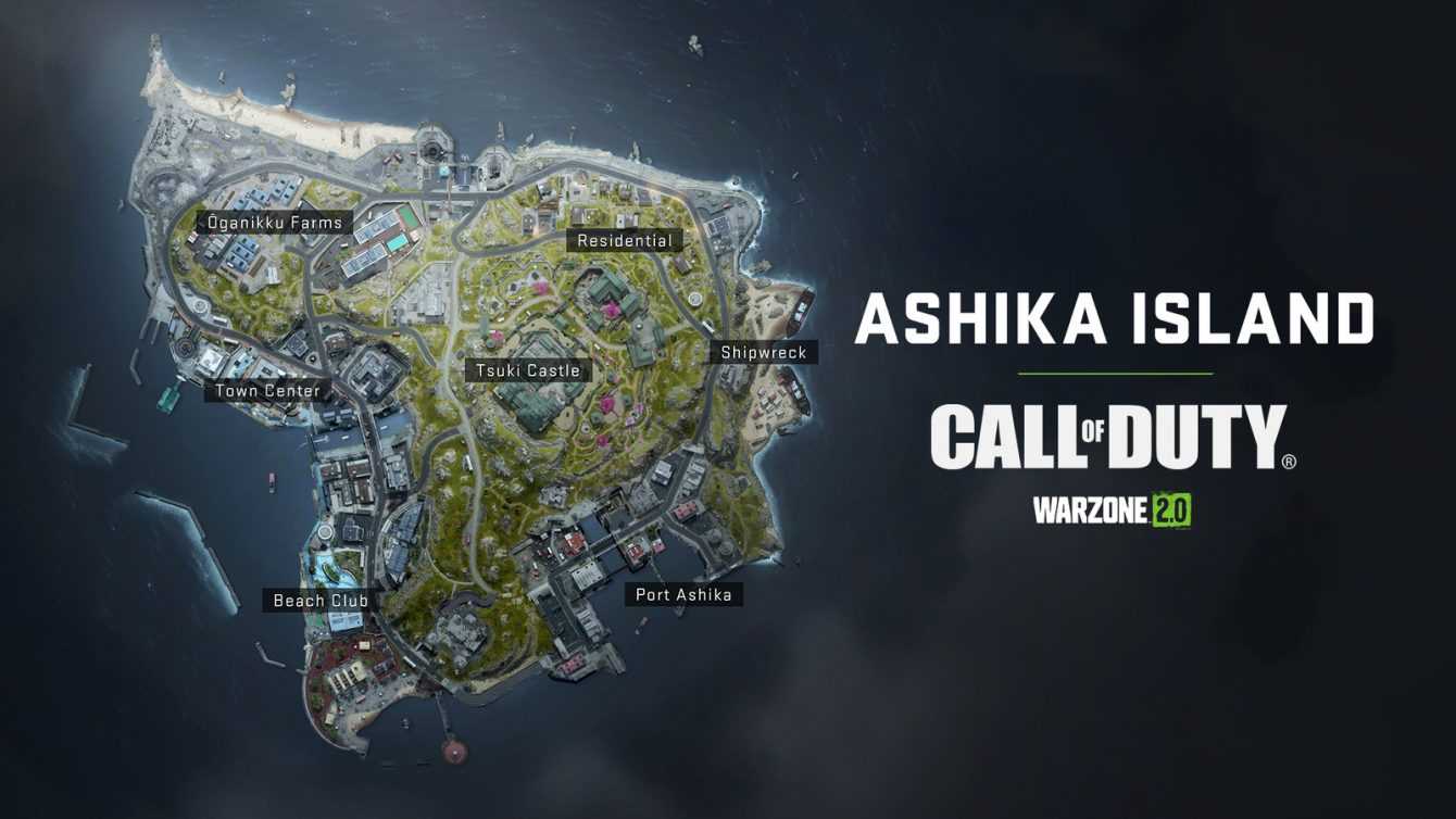
Ashita Island – Warzone: guide to the new map Ashika Island
Ashita Island it is also known by the name of “sea lion island”, and is part of a small archipelago located near an unknown location within the Asia-Pacific area. Recent communications indicated that the island is currently being used as a transit point by the ultranationalist group Connie. Among the many activities of the group, it also transports chemical and bacteriological weapons, and according to information obtained from ***TOP SECRET***further dangerous and fearsome weapons would be shipped from a suspicious biolaboratory facility located at Al Mazrah.
Initially Ashika Island it was used to become a tourist destination. but the development of the island stopped in the mid nineties due to ***TOP SECRET*** and because of the incredible work of ***TOP SECRET***. The reasons for this interruption have never been publicly revealed. Since then, movements into and out of the island have been severely limited and controlled.
Recently intercepted communications suggest that individuals belonging to the Shadow Companyunder the guidance of ***TOP SECRET***, have taken control of the island and are apparently on the hunt for members of the group Connie. Although this location appears abandoned, it is whispered that Konni operators are still very active in this conflict zone. Regardless of which spot you are on, therefore, it is highly recommended that you maintain the utmost caution.
Ōganikku Farms – Warzone: Ashika Island new map guide
Most of the northwestern sector of Ashika Island it is made up of a mix of agricultural, residential and industrial areas, as well as old coastal defense structures. Let’s go and see together which are the most interesting points of this part of the island.
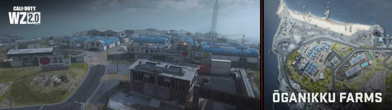
Observation area and ruins
At the northwestern tip of the island is a communication tower (one of three easily identifiable towers throughout the island), located on a narrow strip of land with sand, rocks and a seawall. There is also a large pile of decaying concrete and two war structures being demolished.
North beach
A flat, sandy beach with partially submerged breakwatersscattered boulders and an access to the main island, as well as the water treatment plant to the east.
Greenhouses
A large agricultural structure with a courtyard, warehouses and eight greenhouses, all with a number on the roof for easy location. Different crops are found here (as indicated by the pictures of fruit or vegetables on the walls). To the southeast are both the main entrance and other maintenance warehouses.
Point of Interest: Town Center – Warzone: Ashika Island New Map Guide
In the western area and part of the southwest area of the island you will find a bay with impressive seawalls. Northwest of the main undersea channel are the area of the Ferry Terminal and facilities for tourists. Cross the canal bridges to reach the hotel and the market district, with an additional petrol station and the semi-circular structure of City Hall.
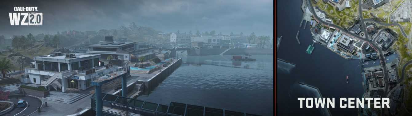
North dam
Going further towards the ocean, they are found a pair of L-shaped concrete reefs submerged in the seabed to prevent tides from causing floods. While this area can be accessed, it offers limited possibilities for hiding, unless you like to lurk just below the surface of the water. To top it all off, there is a small area for launching boats.
Ferry Terminal
Thanks to a covered steel pier, visitors could disembark from the ferries who once came often to the island… until the recent hostilities began. Through this pier you can quickly access the tourist center. You can also reach the parking lot, which is circular in shape, and the toilets (also with a circular structure).
Tourist center building
In this building white and concrete, stained by precipitation, visitors can find information (including a map of the island), as well as a small gift shop and kitchens. Operators may discover some interesting lines of fire towards the farm area and Town Center.
Event Center Building
Parallel to the blue concrete promenade, which continues roughly east and southeast until it reaches the aquarium (which has a similar color), is the event center building. This property is medium in size and is distinguished by signage and solar panels on the roof. Inside, there is a reception area and main ballroom with skylights.
Service station
A small service station that offers all vehicle repair and refueling services you already know, plus great road access to the rest of the island.
Science center
Backed by a stone wall to the east and close to streams, that’s it a modern science center, which has various access points inside and to the roof. This structure, shaped somewhat like a U, has two floors (with a mezzanine balcony overlooking a main atrium, a staircase leading to the roof, and an easy-access cable to climb up.
River channel and bridges
The western entrance to the internal waterways beneath the island is accessible via the canal, over which there are two bridges. The sloping concrete banks are also easily accessed. Note that the metal arches of the pedestrian bridge are also light blue.
South Dam and floating gas station
The port south of the open shipping channel features mostly calm waters, a floating service station located on a pontoon for refueling and repairing water vehicles, and concrete stairway access to the main island. If you don’t care about having cover, you can use the dam area to stand in position with the sniper rifle. Look at the tidal zone below the aquarium to find a leak point under the main entrances.
Market district and hotel
A small group of warehouses with stalls selling various local products. The niches and roofs offer many possibilities for movement. You also have easy access to the water and canal. To the east and across the main road is a hotel with a ground-floor atrium, sushi bar, cable-scramble to the upper floor, two luxury bedrooms, and rooftop access.
Service station
South of the market is a service station for quick refueling and vehicle repairsa circular restroom near the concrete waterfront, and quick access to the bay or nearby City Hall.
Municipality
Modern and imposing structure in the shape of a semicircular “slice” when seen from above, this building is a maze of glass and concrete. Inside there is a large open plan ground floor, escalators leading up to a small kitchen and a mezzanine with display windows. Then there is an upper floor, with a Zen garden both inside and out. The rocky area behind the structure offers shelter and access to the castle gardens.
Point of Interest: Beach Club – Warzone: Ashika Island New Map Guide
Further southwest of Town Center and to the east of the port they are found an aquarium and the Beach Club. This area also offers outdoor swimming along the southwest ocean shoreline. Parts of this area are easily spotted if you skydive, as the trails are a vibrant aquamarine color.
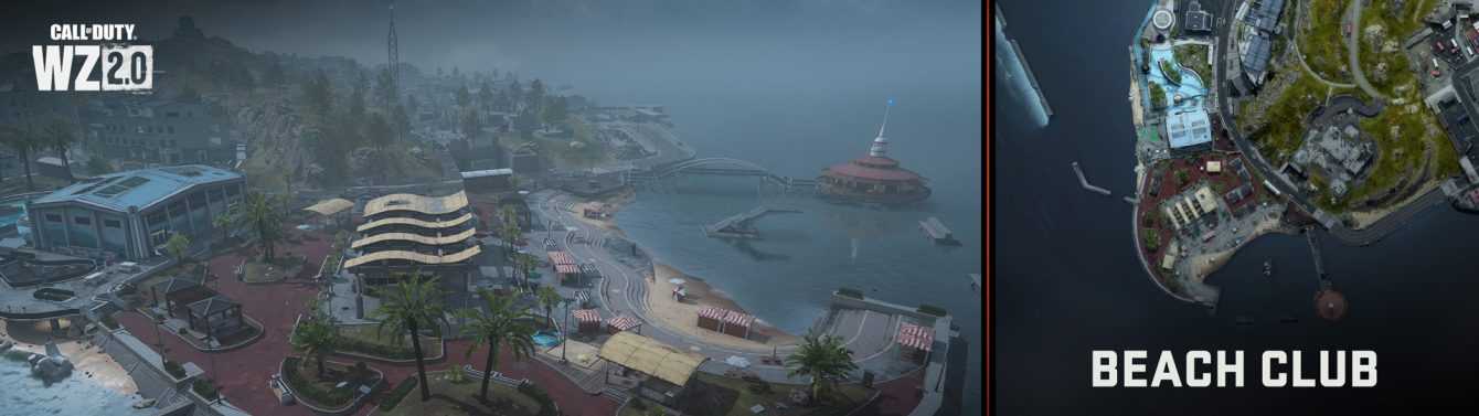
Acquarium
Many of the paths north of the aquarium are painted light blue, making them easy to locate even from great heights. There seems to be no life in the aquarium, which is made up of a large exhibition hall, a small parking lot and, under the gray elevated walkway, an area where the tidal water ends up.
Beach Club and bathrooms
As can also be guessed from the color of the driveways, the burgundy colored paving leads you towards a large barbecue area, four small sealed huts and the main Clubhouse, partially open to the outside. This main structure has two bathroom areas and, in the upper area, a bar.
Beach and observation point
A series of low, curving concrete steps leads to a small beach, an ocean cove with a diving board surrounded by a breakwater, a modest-sized car park, and a pedestrian bridge leading to a pier with a circular lookout . What secrets are hidden under the spiral staircase in the centre?
Demolition yard
The picturesque landscape of the Beach Club it is only partly ruined by a demolition site located on the cliff just above. At the top of the cliff are the remains of a structure that is now only a half-destroyed mixture of concrete and rods. Note the paths that lead from here to the town hall and castle.
Point of Interest: Tsuki Castle – Warzone: Ashika Island New Map Guide
The highest area in the center of Ashika Island sees stand out an ancient castle with various fortifications and a natural defence, consisting of a hill, on the south-west side of the structure. It is a vast plateau with low ramparts, cherry blossoms and a number of secondary structures scattered in various places. Watch out for combat opportunities, but don’t forget to look down – underneath this fortress you can find a culvert and an underwater base!
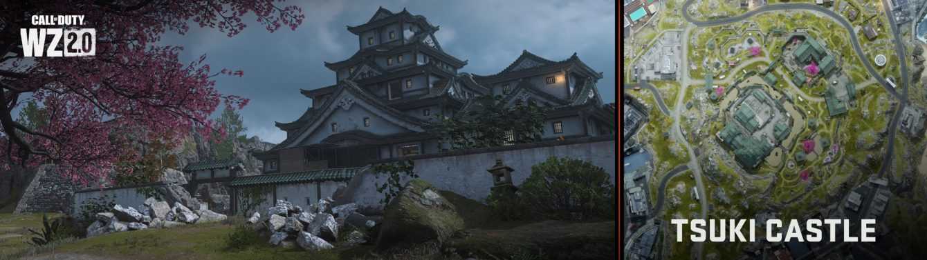
Main stronghold
Although the ancient walls of this imposing castle have been scarred by recent hostilities, however, there are still plenty of hiding places, access points and places to explore, both above and below ground. The inner defensive ring of the fortress begins with a moat on three sides (hills in the rest of the area prevent the moat from connecting with the entire base). The walls of the moat offer openingsleading you to a walled inner courtyard with a “dojo” and an adjacent structure with a mobile radar.
In the courtyard there is also a small outer building recently used as a barracks. In all of this, the main structure of the castle towers over the others. This building, with a vague L shape, has a…