
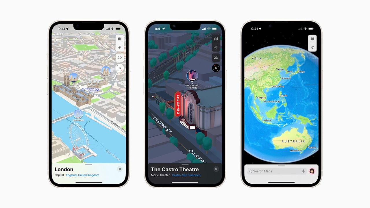
Apple, among the various novelties of iOS 15, introduced in Maps the three-dimensional view in some cities, and the company said it plans to expand the number of cities where the feature is available. As of now, iOS 15 users can live Londra, Los Angeles, New York City in a richer and more complete way, but many more cities will arrive in the coming months.
Apple Maps introduces 3D cities to iOS 15
With the release of iOS 15, Apple Maps gets its biggest update ever with an experience in cities that offers rich detail, driving routes with better navigation, immersive walking directions shown in augmented reality, and much more. The update, which expands on the new map that Apple took years to build from scratch, is now available at London, Los Angeles, New York City and San Francisco Bay, with other cities on the way.
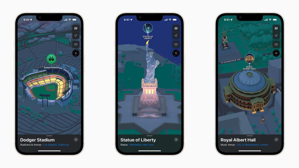 Photo credits: Apple.
According to a blog post from Apple, this new city map experience will also be available soon at Philadelphia, San Diego e Washington, D.C. Support for other cities, including Montreal, Toronto and Vancouver, will be available next year.
The new functionality 3D introduces a new way to navigate cities via Apple Maps by offering unprecedented detail for neighborhoods, marinas, buildings and more. Can be seen three-dimensionally the various cities, with road signs and hundreds of specially designed landmarks. These include the Dodger Stadium in Los Angeles, the famous Statue of Liberty in NY or the Royal Albert Hall in London.
“We are thrilled to deliver the new Apple Maps experience. Maps is the best way to navigate the world – it’s easy to use, well designed and built with privacy at the fore. With this update, we are pushing Maps even further, providing more ways for users to discover the natural beauty of the world and explore cities through a new 3D view, ”he said. Eddy Cue, Apple’s Senior Vice President of Services. “Our goal has always been to build the best and most accurate map in the world.”
The directions for the lanes and the pedestrian crossings arrive
Maps now also offers more road details to help drivers navigate cities more easily and safely. The lanes to turn, those for buses and taxis e the pedestrian crossing they are clearly displayed for easy navigation at busy intersections.
This new information – at least in the United States – also helps to drive the freeways where there are complex interchanges. Overlapping roads are represented in a 3D street-level view, making it easier to see upcoming traffic conditions or the best lane for an approaching exit. The route planning provides the estimated arrival time for future departures based on the expected traffic. In addition, the new navigation will be available via CarPlay later this year.
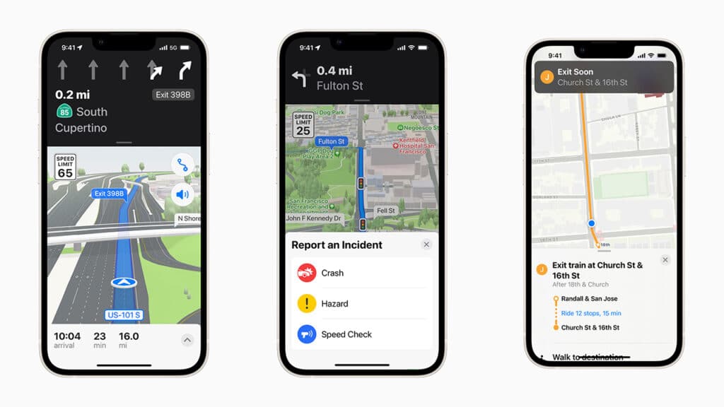 Photo credits: Apple.
Maps now offers major improvements for the public transport. Nearby stations in some cities are prominently displayed at the top of the screen and users can pin their favorite lines on Maps. Once you have selected a transit route, Maps will notify you when it is time to get off the vehicle.
The new iOS 15 operating system also introduces a step by step guide with augmented reality. Users can simply lift their iPhone to scan buildings in the area and Maps generates an extremely accurate location to provide detailed directions that can be viewed in real-world context.
The other features of Maps
- The new functionality Look around allows you to enable street view to see the world through an interactive 3D experience.
- the cycling directions now they show the elevation, how busy a road is and if there are stairs along the way.
- The Speed Cameras they are now signaled and the user is warned when a speed check is approaching.
- It is also possible share an estimated arrival time with family, friends and colleagues with a simple touch.
- Accident reports they allow to report in a simple and safe way an accident, a danger or a speed check along a route. Just tell Siri “There is an accident ahead” or “There is something on the road”. Users can also report when incidents shown on the map have been eliminated, all while keeping their attention on the road.
- Flyover offers a way to see selected major metropolitan areas with engaging, photorealistic 3D views.
- Favorites provides one-touch navigation to frequently visited places.
- Maps per interior as airports and malls allow users to simply open the Maps app and see what level they are at, search restrooms, and even find out which shops and restaurants are open.