
With the products of the Garmin inReach range you can spend your holidays in the mountains without fear of getting lost, in total safety!
Compared to a few decades ago, the mountains today represent a very popular holiday destination for Italians, once generally accustomed to spending their summer in seaside resorts. From traditional activities such as trekking and mountaineering to new high-adrenaline disciplines, the high altitudes attract thousands of people every summer, very often with little outdoor experience. In this context, awareness of the risks that can be encountered in mountain areas, such as that of not always being able to enjoy telephone coverage, is considered a marginal detail of our moment of leisure, hiding instead a strong risk component. To respond to the request to communicate wherever you are, Garmin offers inReach satellite technology, a system capable of making our outings safer while always keeping in touch with the rest of the world. Two products, in particular, have quickly become must-haves: Garmin inReach Mini and Garmin GPSMAP 66i, satellite messaging and localization devices that, thanks to Iridium satellite coverage, guarantee everyone to be able to communicate their position anywhere.
This summer will be “outdoor boom”. Even more than last, the forecasts for the upcoming season give the mountain as a very popular destination for Italians who will look for fun in outdoor activities. The mountain, in fact, offers multiple possibilities and for various levels of experience: whether it is simple trekking to high altitude shelters or climbing on panoramic via ferratas, the mountain will be able to attract those who want a real escape from the cities. .

A summer outdoors: holidays in the mountains?
Hiking, mountaineering, mountain biking: many activities, practicable at any level, but which require particular attention to safety, a factor which cannot be ignored. The mountain is capable of giving extraordinary emotions, but at the same time it requires respect for the rules, because the mountain environment can also reserve unwelcome surprises: a sudden change in the weather or a slide in a slightly exposed stretch are the elements that risk ruining a moment of fun. GSM coverage in the mountains is not uniformly guaranteed, and this is a weak point of our safety in outdoor environments. InReach technology allows you to do in the mountains, what our mobile phone allows us to do without any kind of problem in the city.

What to do if the cellphone does not pick up?
Whether you are in the hills behind your home or on a Himalayan expedition, communication is essential, and that is why Garmin has developed an innovative, simple and functional solution, able to ensure assistance in an emergency anytime and anywhere. Leaning on the satellite constellation Iridium, the Garmin inReach technology it is able to send distress call messages, even when you cannot enjoy telephone coverage.
Garmin devices that integrate the inReach system allow you to communicate your geo-localized position, not only with text messages but also by sharing the link of the inReach MapShare portal: in this way anyone of their loved ones can always check our position. But it is in an emergency that inReach technology becomes essential: Garmin IERCC (Garmin International Emergency Response Coordination Center) the international emergency management center, active globally 24 hours a day, provides support in case of need by receiving the request message and immediately activating assistance and recovery procedures. An important factor is that of Fr.oter interact with the rescuers, receiving first aid information (if possible) and updates on the state of recovery: an advantage, on an emotional level, which is fundamental for anyone who has suffered an injury or trauma. From simple enthusiasts to outdoor professionals, Garmin inReach caters to everyone who they live the natural environment in all its forms, not just for passion. But also for work. Among the tools that Garmin offers with its wide range, we find inReach Mini and the portable GPSMAP 66i. Aimed at two different user targets, to guarantee 360-degree outdoor safety.

Garmin inReach Mini satellite communicator: security at your fingertips
Garmin inReach Mini is the compact solution of only 100gr which, through the Iridium system, allows you to have a two-way communication even where the mobile phone cannot work. Lightness and practicality: its dimensions make it ideal for runners and bikers. In addition to sending and receiving text messages and e-mails, it can send emergency SOS: once the appropriate button is pressed, the position is sent to the Garmin IERCC international emergency coordination center, thus guaranteeing assistance and immediate assistance in case of need, wherever you are. It integrates a rechargeable lithium battery with ample autonomy: from 90 hours with sending the detection of your route every 10 minutes, up to one year in stand by mode.

The price is 349,99 Euro, to which is added the subscription for the transmission of satellite data.
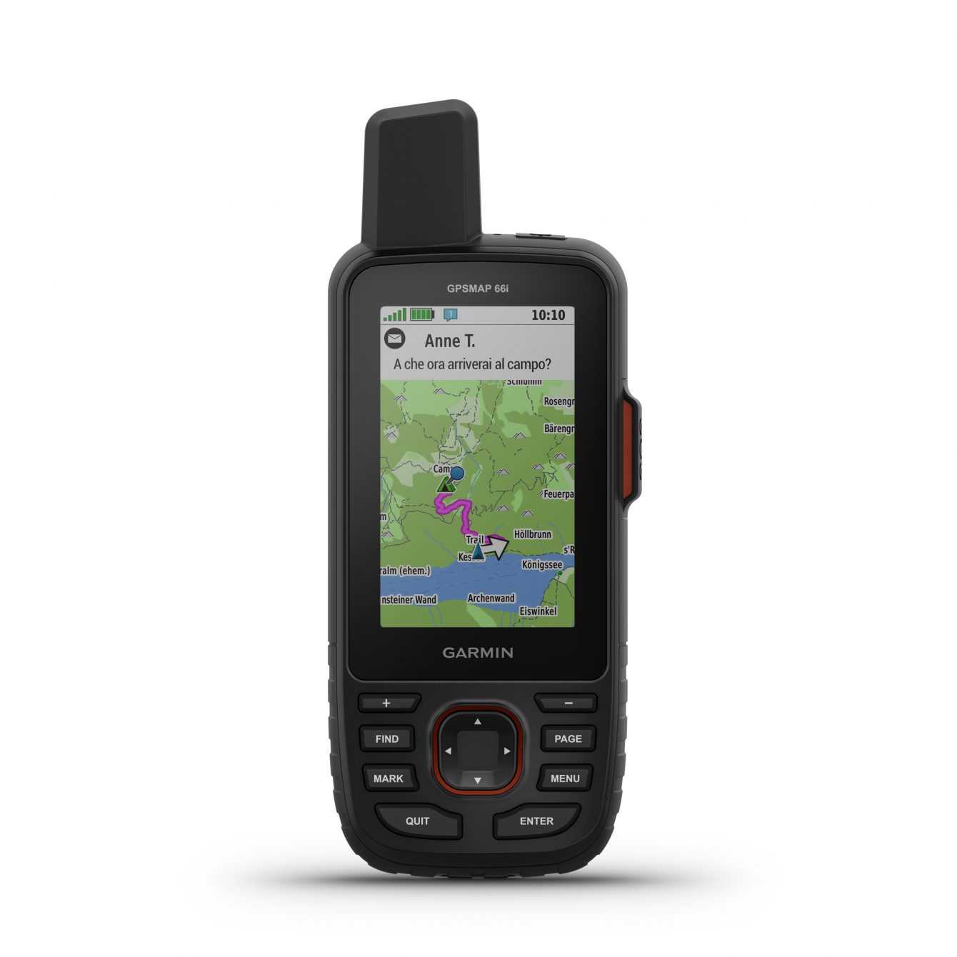
Garmin GPSMAP 66i: always in touch, step by step
For more experienced hikers, or for those who want to rely on the navigation and orientation functions present on Garmin handhelds, GPSMAP 66i is available: precise and reliable geolocation with GPS / GLONASS / GALILEO satellites and sharing of messages and position with the Iridium network. Barometric altimeter, electronic compass and preloaded TopoActive Europe cartography clearly visible on the display a colori da 3”, to allow the user to consult in detail all the characteristics of the territory: altitude lines, roads, coasts, rivers, peaks and panoramic points. ù
It offers great potential for the use of maps, allowing the implementation of maps with greater detail, as in the case of Trek Map Italia V6 PRO, the Italian topographic map produced by Garmin Italia, or as the BirdsEye cartography that can be downloaded for free on the GPSMAP 66i also via Wi-Fi connection: a unique navigation experience with high-resolution satellite images of the places you will cross. Rugged, shock resistant and waterproof, it integrates a rechargeable battery with an autonomy of up to 35 hours, with position tracking every 10 minutes, and up to 200 hours in “Expedition” mode, with tracking intervals every 30 minutes. Trip planning, activity archiving, saving points of interest are guaranteed by GPSMAP 66i and can also be synchronized and archived on your smartphone via the Garmin Explore app, or on your PC with the Basecamp software.
The price is 599,99 Euro, to which is added the subscription for the transmission of satellite data. That’s all for now, more information is available on the official website. Keep following us!